Sorrento Hillwalk
climb Monte San Michele 1444m "La Molare" highest point on Sorrento peninsula
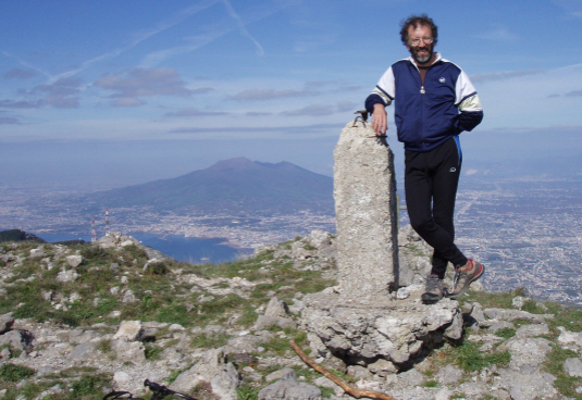
On the summit, Vesuvius and Bay of Naples behind.

Difficulty
MODERATE: approx 5mi/8km and 500m ascent, essentially on easy maintained and marked trails, occasionally rough, occasionally a modicum of exposure.Time
Allow 3-5+ hours. Leisurely 5hrs recommended.Description
A splendid walk on the high limestone escarpments through delightfully varied fauna with outstanding views, to the summit of the highest point on the Sorrento Peninsula. Start from the Monte Faito cable car station (€5,30ow €7,50ret.) at the end of the platform at the railway (Circumvesuviano) station in Castellamare di Stabia. The cablecar whisks you up 1000m+. From the top station pick up trail 36 as per main description.Season
Spring - end October. Out of season the cable car is closed and there is usually snow to contend with Nov - Spring. Cable car: first bin is 7.30am last down ?6.30pm high season (July/August), otherwise 9.30am/4.25pm.Maps and info
Ah maps! Well the trouble is that for those of us used to the OS or French/Swiss maps, Italian maps are, in a word, rubbish! The best topographic maps on offer are the 1:30,000 CAI and the 1:25,000 "carta touristico informatica" for Monti Lattari, both with 25m contours. The topographic base seems accurate but with such an interval obviously lacks detail and both lack clarity. Worse, the depiction of the trails cannot be relied on. However for this particular walk salvation is at hand (as I belatedly discovered) in the form of a 1:12,500 map segment produced by local cartographer and guide Giovanni Visetti on which the trails at least are admirably clear and accurate (and from which I have used scans for this page). I obtained mine from the bar at the top cable car station for a mere euro.
More info: there is a book by J. Tippett on walking in the area (mostly low lying/coastal walks and rambles).
Thanks to local guide Maurizio De Rosa for his help. He regularly works with english speaking clients.
Photos © Marcus Brown
search terms
Hillwalk to summit La Molare - Sorrento hillwalk - walk Sorrento Peninsula - hillwalk Bay of Naples
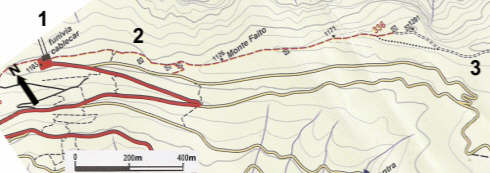
1. Exit the cable car station to the L. up the steps you will see trail sign 36 (336 on Visetti's map)on the trees.
2. Good views of the Bay of Naples. In a short while come up against a stout fence surrounding a radio station.
Ignore the track R that leads to the road. Scrutiny reveals the path continuing around the NE (L) side.
3. Continue along the track, when it splits angle R to the road to...(map below)
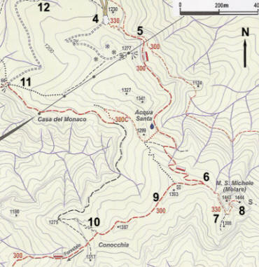
4. .. a parking area on the hairpin bend. No sign posts but pick up the
trail off the E side: look for red paint! Ignore another trail heading SW.
5. In Oct '09 this trail junction had a branch across the L turn to keep walkers on the trail to the peak.
6. Past a spring (water OK according to local guide), to well signed trail junction near ridge crest.
7. Follow trail round to small col below summit. Views already terrific.
8. Stony but straightforward path to top passes a Madonna in a cave. Photo heaven.
9. Retrace steps then continue to pass mobile phone masts (no liability for microwaved brain!).
10. Trail junction is signposted on the treeless S slopes - main trail continues to Positano.
Down and R (NW) to pick up a track.
11. Track circumnavigates steep valley. Turn a corner and enjoy transition to
chestnut forest again as the arid S side is left behind.
12. Follow track to rejoin road next to disused showjumping arena.
Back up road to hairpin (4) and trail 36 and return to cable car. ENJOY - I did.
 |
Now see  image
image
image
image
 image
image
 image
image
image
image
image
image
image
image
image
image
image
image
image
image
|
